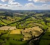
With the support of a Lincolnshire farmer, we are piloting a revolutionary new way to combat a persistent crop weed which could save arable farmers thousands of pounds a year and costs the UK economy an estimated £400 million a year in lost crops.
Blackgrass competes directly with major cereal crops such as wheat and rapeseed, and sheds huge numbers of seeds enabling it to spread quickly across a field. If left unchecked, blackgrass can render land completely unviable for crop production. Farmers commonly use a blanket approach to deal with blackgrass if it is present.
Herbicides are applied to all parts of a field to try and stop growth as it can be difficult for farmers to use a targeted approach. This has meant blackgrass has developed significant resistance to conventional herbicides, making it even more persistent than other arable weeds.
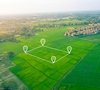
We are involved developing a system where drones can survey farmers’ fields from above, aiming to identify pockets of blackgrass, and use dedicated software to produce a map of those affected areas and measure the variability of the weed infestation. This data can then be used to influence how the farmer deals with the problem, such as cropping certain areas of the field differently, applying varying rates of herbicide, or altering drilling dates and rates depending on the size of the field and the prevalence of blackgrass within it.
Associate Partner, Robert Knight, said: “Blackgrass is the bane of so many arable farmers, but targeted methods to stop it have not really been developed, which costs the industry millions every year. It’s not a weed you can scrimp on but there are opportunities to target and make savings. If farmers find blackgrass in their fields in the summer, they understandably take a safety-first approach and treat the whole field in the next crop. However, this approach costs much more than if they had the data to take a more precise approach.
“The methods we are developing will allow farmers to directly target compromised parts of their fields most heavily and reduce input cost where the weed pressure is less, which keeps yields high. There may be more drastic management changes required in severely infested areas, such as delaying drilling, increasing seed rates and herbicide use, or not cropping at all.
“Our drone partner in this project, TAC360 has demonstrated excellent variation indexing, which identifies the zones of weeds nicely. The farmer we’re working with is building application mapping from this data, which enables us to build treatment maps to manage areas differently. We estimate this could save farmers around £100 per hectare in chemical alone but also importantly manages risk. We are looking forward to finalising the process – it could help farmers around the country save thousands every year.”
Click here to find out more about our comprehensive geospatial services.